Friday, December 27, 2013
Tuesday, July 16, 2013
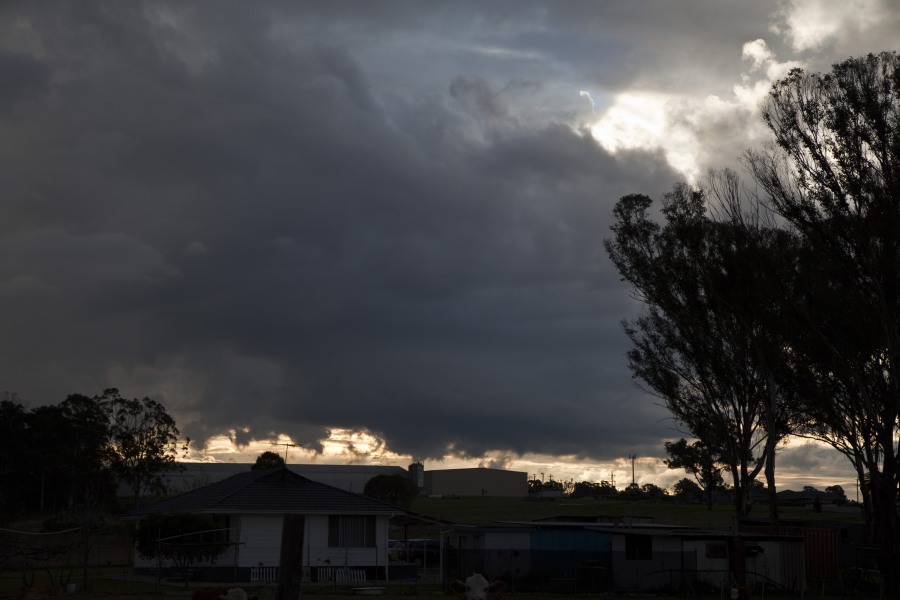
Flash flooding from Winter Storms in Sydney 16th July 2013
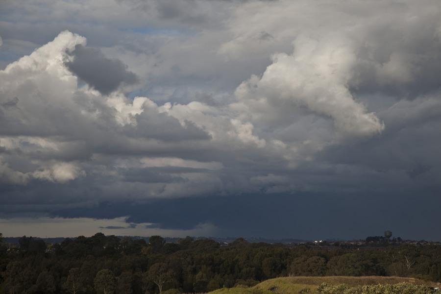
Storms western Sydney 16th July 2013
Flash flooding at North Ryde with this storm
 A storm produced flash flooding as 15mm fell in 15 minutes at North Ryde! It is unusual for storms to occur during winter so this storm cell was a surprise particularly its intensity! The storm was spawned near the Riverstone Schofields corridor and intensified as it moved over Baulkham Hills Castle Hill district finally dumping torrential rain over the North Ryde area. The storm then drifted east and gradually weakened. A boy was swept into a creek or river at the height of the storm.
- Storm weakens rapidly near sunset
Flash flooding from Winter Storms in Sydney 16th July 2013
Friday, June 28, 2013
Developing East Coast Low

A strong upper trough will move into the region Sunday and help deepen in an existing surface trough along the coast. An East Coast Low is likely to form near the SE QLD coastline. The forecast position and intensity of this low varies between the weather models but the most likely outcome at this stage is for the Gold Coast, Northern Rivers and northern parts of the Mid North Coast to cop the worst of it – especially during Monday. Strong to gale force wind gusts may also develop along the coastal strip. Some locations may see falls of 150-200mm over 48 hours – though this looks much more likely for coastal areas.
Thunderstorms are possible in the mix as instability is present both Sunday and Monday – expect heavy rainfalls if you’re under one of those.
Rain areas and showers should persist into Tuesday clearing from the north with Wednesday fining up. Then several days of clear skies are expected.
Attached is the rainfall forecast map from the BoM for Monday.
Developing East Coast Low
Tuesday, June 25, 2013
Snow NSW Northern Tablelands 25 June 2013
Approx 2cm of snow fell in the Black Mountain area and 1cm in Guyra between 4 and 5.30am 25 June.
Further wet snow and sleet fell across the region during the morning but it did not accumulate further. 850 hPa temps needed to be 1 C lower for a better cover.
Snow NSW Northern Tablelands 25 June 2013
Friday, June 21, 2013
Extreme Lightning El Reno Tornadic Supercell 31st May 2013
Some crazy lightning was observed on this tornadic developing supercell. It was so intense we remained in the vehicle during the barrage – and as you note in the video, I took the aerial into the car! I understand that the probability was low but chaser vehicles have been struck in the past!
Extreme Lightning El Reno Tornadic Supercell 31st May 2013
Thursday, June 20, 2013
Flood Watch for parts of NSW

A large part of the NSW coast is on flood watch with an east Coast Low expected to develop during Monday. Models are not consistent with the timing or placement of a possible low, or ever whether heavy rainfall will push inland much. However the BoM have issued a flood watch
FLOOD WATCH FOR MINOR TO MODERATE FLOODING ON THE PATERSON, WILLIAMS, WYONG, NEPEAN, GEORGES AND THE TIDAL ZONES OF THE COOKS AND WORONORA VALLEYS.
Issued at 12:45 pm EST on Friday 21 June 2013
Note: This Flood Watch is a “heads up” for possible future flooding along all rivers and creeks within a nominated valley and is NOT a Flood Warning [see note below].
From late Saturday night (22/6/13) through to Monday night, heavy rain is expected over coastal districts between Narooma and Seal Rocks. This rain is likely to cause local and main river flooding.
At this stage there is a greater than 70% chance of flooding along the following river valleys:-
Paterson and Williams Valleys – minor to moderate flooding
Wyong Valley – minor flooding
Georges River Valley – minor flooding
Nepean River Valley – minor to moderate flooding
Heavy rain combined with King Tides over the same periods may also expose the tidal zones of the Cooks and the Woronora Rivers to minor flooding.
This Flood Watch means that people living or working along rivers and creeks must monitor the latest weather forecasts and warnings and be ready to move to higher ground should flooding develop. Flood Warnings will be issued if Minor Flood Level is expected to be exceeded at key sites along the main rivers for which the Bureau of Meteorology provides a flood warning service. Across NSW about 75% of Flood Watches are followed by flooding within the catchment.
FloodSafe advice is available at www.ses.nsw.gov.au
For emergency assistance call the SES on telephone number 132 500.
For life threatening emergencies, call 000 immediately.
Flood Watch for parts of NSW
Wednesday, June 19, 2013

Saturday, June 15, 2013
El Reno wedge tornado survivors
 This photograph is a closeup view of the vehicle. chances of survival becomes slim when the vehicle is crushed and with glass breaking debris being hurled around at high speeds.
 This vehicle was one of the victims if this tornado. The axle lay on the opposite side of the road – was not sure from which vehicle it came from.
El Reno wedge tornado survivors
Monday, June 10, 2013


Extreme Storm News image

This is a downed power pole on Meridian Avenue near the Oklahoma City Airport. Apparently a tornadic track did end up the region but not sure if this particular power pole was downed by powerful winds. There were two phases of the supercell. The first contained the tornado and then the supercell sent a powerfull region of outflow which caused straight line wind damage and wih warnings of localised tornadoes.
Extreme Storm News image
El Reno Tornado Power Flashes 31st May 2013
Check out the power flashes inside the rotating rain. We are headed east and the camera is pointing WSW towards a region rapidly rotating rain – the tornado at times cane be seen inside the rain. The power flashes are evidence of this as it brings down power poles.
El Reno Tornado Power Flashes 31st May 2013
Monday, June 3, 2013
Violent Wedge Tornado El Rino 31st May 2013

The El Rino tornado developed on a day exhibiting potent conditions – an environment with extreme CAPE and an explosive atmosphere. The tornado emerged from the mass of cloud and instantly began to produce vorticies! We were only about 1km from the tornado.
<iframe width=”560″ height=”315″ src=”http://www.youtube.com/embed/t5JPQrCRd0o” frameborder=”0″ ></iframe>
Violent Wedge Tornado El Rino 31st May 2013
Thursday, May 23, 2013
NSW East Coast Low 23-24 May 2013
An East Coast Low developed overnight off the Mid North Coast of NSW. ALready significant rainfalls have occured with a flood watch for the Bellinger and Nambucca Rivers.
This morning the low is east of Coffs Harbour and expected to move N then NE. The shear profile later today supports a possible tornado mainly in the coastal area. The BoM warning reflects the threat

for destructive winds, heavy rain and damaging surf
for people in the Northern Rivers and Mid North Coast forecast districts
Issued at 6:43 am EST on Friday 24 May 2013.
RAIN, WIND AND SURF INCREASING ON THE NORTH COAST TODAY.
Weather Situation
A low pressure centre off the Mid North Coast is deepening. Rain, wind and surf will increase along the Mid North Coast and Northern Rivers during Friday, with destructive wind gusts possible from intense periods of rain along the coastal fringe.
Destructive wind gusts of up to 125 km/h are forecast for the Mid North Coast forecast district during Friday, extending to the Northern Rivers forecast district during late afternoon or evening.
Very heavy surf which may lead to localised damage and coastal erosion is forecast for the Mid North Coast forecast district. Beach conditions in these areas could be dangerous and people should stay well away from the surf and surf exposed areas.
Heavy rain which may lead to flash flooding is forecast for the Mid North Coast forecast district and southern parts of the Northern Rivers forecast district.
The State Emergency Service advises that people should:
Move vehicles under cover or away from trees.
Secure or put away loose items around your house, yard and balcony.
Keep clear of fallen power lines.
Don’t drive, ride or walk through flood water.
Keep clear of creeks and storm drains.
If you are trapped by flash flooding, seek refuge in the highest available place and ring 000 if you need rescue.
For emergency help in floods and storms, ring your local SES Unit on 132 500.
NSW East Coast Low 23-24 May 2013
Tuesday, May 21, 2013
Tornadoes Texas and Arkansas
 More tornadoes are expected some significant ones within bowing segments along the extensive squall line that already exists across Arkansas and Texas. The most likely risk for severe weather will be high winds.
Tornadoes Texas and Arkansas
Monday, May 20, 2013
Tornadoes Oklahoma and North Texas 20th May 2013
 There are some tornadoes expected again today in Oklahoma and Texas. Tornado watches extend into Kansas and Missouri as well as most of Oklahoma and north and central Texas. Reports of damage in Moore along I-40.
Tornadoes Oklahoma and North Texas 20th May 2013
Extreme Storm News image

Tornado from Daniel Shaw in Kansas! Nice! More tornadoes will be posted from Oklahoma
Extreme Storm News image
Sunday, May 19, 2013
Oklahoma City Supercells and tornadoes 20th May 2013

503PM CDT EXTREMELY LARGE AND VIOLENT TORNADO JUST NORTHEAST OF OKLAHOMA CITY NEAR CARNEY OKLAHOMA. THIS IS AN EF4/EF5 TORNADO. THE ONLY WAY TO SURVIVE THIS TORNADO IS BELOW GROUND. BASHAM
Oklahoma City Supercells and tornadoes 20th May 2013
Friday, May 17, 2013
Moderate Risk including giant hail 19th May 2013
 Read the following notes from the SPC for a Moderate Risk in NW Kansas and SW Nebraska:
LATEST SHORT RANGE MODEL GUIDANCE INSISTS STRONG HEATING WILL OCCUR ACROSS SERN CO INTO NWRN TX. THIS SHOULD ALLOW DRYLINE TO MIX TO A POSITION NEAR THE OK BORDER…ARCING NWWD TO A SFC LOW OVER WRN KS BY 19/00Z. WITH SFC DEW POINTS EXPECTED TO RISE WELL INTO THE MID-UPPER 60S EAST OF THE DRYLINE…EXTREME INSTABILITY MAY DEVELOP ALONG A CORRIDOR FROM WRN OK INTO NWRN KS WHERE SBCAPE COULD EXCEED 4000 J/KG. AS TEMPERATURES WARM INTO THE LOWER 90S ACROSS THE TX PANHANDLE INTO SWRN KS INHIBITION WILL BE NEGATED AND DISCRETE SUPERCELL STRUCTURES ARE EXPECTED TO DEVELOP. HAVE INCREASED THE SEVERE PROBS ACROSS PORTIONS OF KS/NEB AS THIS PORTION OF THE CNTRL PLAINS SHOULD EXPERIENCE STRONGER DEEP LAYER SHEAR…POTENTIALLY SUPPORTIVE OF TORNADOES. LATEST 12Z NAM FORECAST SOUNDINGS STRONGLY SUPPORT SUPERCELLS ACROSS THE MDT RISK REGION WITH SBCAPE IN EXCESS OF 4000 J/KG WITH SFC-6KM SHEAR ON THE ORDER OF 40KT. ADDITIONALLY…VERY LARGE HAIL MAY ACCOMPANY ANY SUPERCELLS THAT DEVELOP SATURDAY. LATEST FORECAST HAIL ALGORITHMS SUGGEST HAIL COULD EASILY EXCEED BASEBALL SIZE WITH ORGANIZED ACTIVITY.
Interestingly, the last line indicates the possibility of extremely large hailstones and there is talk of the possibility of long tracked tornadoes if the storms can move further east into moisture.
Moderate Risk including giant hail 19th May 2013
Thursday, May 16, 2013
Texas tornadoes 15th May 2013
Wedge Tornado near Cleburne, TX – May 15 2013
Today saw some supercells developing with tornado warnings. A wedge tornado caused fatalities south of Dallas after dark as the nocturnal jet really raced in.
Texas tornadoes 15th May 2013
Tuesday, May 14, 2013
Extreme Storm News image
Slow moving thunderstorm observed from near Lismore, NSW this afternoon. Spotted one powerful staccato lightning bolt as the cell cleared to the east on sunset..

Extreme Storm News image
Monday, May 13, 2013
Oklahoma Supercells and Hook Echos 17th April 2013

Oklahoma Supercells and Hook Echos 17th April 2013
Oklahoma Supercells and Hook Echos 17th April 2013
Wednesday, May 8, 2013
Supercell NW Texas Video 15th April 2013
This video depicts the transition of one supercell to another and then the last supercell with beaver tail followed by nice structure with setting sun.
Supercell NW Texas Video 15th April 2013
Thursday, May 2, 2013
Extreme Storm News image

Separation is beginning to occur at this point and a thick beaver tail emerging. Fascinating is the supercell!
Extreme Storm News image
Wednesday, May 1, 2013

Latest news image
This is what the supercell then become so I hope it gives some perspective of how it all transformed!

Latest news image
Latest news image
This is what the supercell then become so I hope it gives some perspective of how it all transformed!

Latest news image

Tuesday, April 30, 2013

Friday, April 26, 2013
Elk City Supercell April 26th 2013

 After a long wait, storms developed in northwestern Oklahoma and intensified as the afternoon progressed. A supercell beast developed near Elk City and moved south east with striated structure. Giant hail fell from this storm in or near Cordell
Elk City Supercell April 26th 2013
Elk City Supercell April 26th 2013
 After a long wait, storms developed in northwestern Oklahoma and intensified as the afternoon progressed. A supercell beast developed near Elk City and moved south east with striated structure. Giant hail fell from this storm in or near Cordell
Elk City Supercell April 26th 2013
Tuesday, April 23, 2013
Snow storm in Minnesota 18th to 19th April 2013

Our main intention on this day was to meet our relatives arriving late night. We knew it would snow but did not anticipate night time snow conditions! The next morning, we got to see the depth of s now that
 had fallen.


Snow storm in Minnesota 18th to 19th April 2013
Snow storm in Minnesota 18th to 19th April 2013
Our main intention on this day was to meet our relatives arriving late night. We knew it would snow but did not anticipate night time snow conditions! The next morning, we got to see the depth of snow that had fallen.
Snow storm in Minnesota 18th to 19th April 2013
Incredible Supercell Structure Clinton, Oklahoma 22nd April 2013


 Michael Bath and I targeted NW Oklahoma – in fact we dropped down from Kansas. It annoyed me because we had no coverage and no data at all for the entire chase! Back to the old days! The first cells struggled whilst we looked at the cells on th Kansas border. A lot of pressure to head up north but we remained on our target. The issue was that the anvils were raining on the updraft air for the first and then second and finally the third storm which favoured a left moving environment. In the distance to the WSW was the struggling cells with structure we liked. So took the gamble and headed towards it.Just NE of Arnett. we had to turn south to escape the hail. I did not realise whilst driving at the time, but our photos showed the split! Nevertheless, our target was always going to be the southern structure. We stopped E of Arnett and filmed the storm with possible wall cloud and beaver tail and it was this time the storm first weakened into a linear structure. We headed east and photographed the storm periodically. The southern section improved and we spent the next 4 hours side stepping the anvil rain south east all the way to Clinton and Weatherford. It exhibited the best structure near Highway 34 north of the intersection with 33 (Leedey). It was here I photographed the vault and thankfully we could remain east to east southeast of the storm. It was one incredible chase and he structure awesome!
Incredible Supercell Structure Clinton, Oklahoma 22nd April 2013